
UTSA geoscientists prepare for October trip to the Arctic
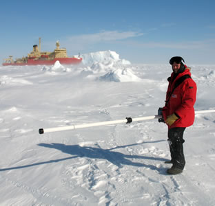
Blake Weissling researching in the Antarctic in 2007.
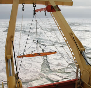
Antarctic expedition photo captures instrument package suspended from a crane collecting sea ice data.
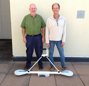
Stephen Ackley and Blake Weissling with new Electromagnetic Induction Meter that will be used in the Arctic in October.
Blake Weissling researching in the Antarctic in 2007.
Antarctic expedition photo captures instrument package suspended from a crane collecting sea ice data.
Stephen Ackley and Blake Weissling with new Electromagnetic Induction Meter that will be used in the Arctic in October.
(May 11, 2015) -- In October, UTSA College of Sciences faculty members Stephen Ackley and Blake Weissling wlll travel to the Arctic as a part of a project funded by the Office of Naval Research (ONR) to study the diminishing ice cover. The pair will join a team of nearly 20 scientists from around the world for the 42-day trip from Nome, Alaska into the Arctic Ocean.
Ackley has conducted research in the polar regions for more than 30 years and has a specific geographic location, “Ackley Point,” named after him. Ackley Point is located on Ross Island, an island formed by four volcanoes in the Ross Sea, near Antarctica. This will be his 12th trip to study polar sea ice, conducted from either drifting ice camps or aboard a vessel.
An assistant research professor in the UTSA Department of Geological Sciences, Weissling has led UTSA students conducting ice research in the Arctic, the Antarctic and at Pico de Orizaba, a volcano east of Mexico City. Ackley and Weissling will travel on the “Sikuliak,” an icebreaking ship making its maiden voyage into the ice.
Project leaders hope to develop methods to quantify how the ice is changing. Satellite remote sensing has captured how the ice surface area has been changing, but accurately measuring the region’s ice thickness from above has been a challenge.
“The Navy is particularly concerned with improving its models for atmospheric sensing and for waves,” said Ackley. “When the ice cover is taken away, then the potential for ocean waves builds up. The waves can be a major factor in any kind of economic development involving oil rigs, shipping, search and rescue efforts, and Navy operations. Large waves can also affect the native residents going out to hunt.”
Weissling added, “We are going to be looking for storm events so we can measure the oceanographic, meteorological, and ice parameters associated with waves. We will be looking at how the waves are interacting with the ice edge, because the ice edge dampens wave fields dramatically.”
The UTSA researchers are supported by an ONR research grant as well as a $500,000 Department of Defense instrumentation grant. They have used the instrumentation grant to purchase sophisticated equipment including radars, a light detection and ranging (LIDAR) system and two electromagnetic induction meters. LIDAR systems incorporate a remote sensing method that uses light in the form of a pulsed laser to measure variable distances to the Earth. The electromagnetic induction instruments will enable researchers to measure sea ice thickness within a few centimeters of accuracy, either on the surface or from the vessel.
Once the researchers return, they envision another two years of data analysis.
After the exploratory trip is complete, UTSA faculty members representing various colleges will benefit. Much of the equipment purchased has additional applications and can be used in the geosciences, civil engineering, architecture and archaeology.
For more about UTSA’s polar research, visit the Laboratory for Remote Sensing and Geoinformatics.
Connect online with UTSA on Twitter, Facebook, YouTube and Instagram.
Events
This academically rigorous mathematics-based summer enrichment program prepares middle and high school students for advanced studies in science, technology, engineering and mathematics (STEM). Participants learn about problem-solving systems, develop greater awareness of STEM careers and strengthen their research skills.
UTSA Main CampusArchaeology 101 will introduce campers to archaeology and build on learned skills through experimental activities (like cave painting, weaving, and garbology).
Center for Archaeological Research, UTSA Main CampusThe camp exposes rising high school juniors, rising seniors and incoming college freshman to the many facets of the criminal justice system. Students will have opportunities to learn the functions of police in society and apply scientific theories to criminal investigations by examining a mock crime scene.
UTSA Main CampusThe Academy for Teacher Excellence Research Center invites you to join us for the Summer Bridging Institute. This institute will focus on being lifelong growers and continually seeking to increase our skills as educators.
UTSA Downtown CampusArchaeology 201 will briefly go over the foundations of archaeology and related skills, followed by a different topic over the course of this week (like skeletal analysis, global cultures, and more).
Center for Archaeological Research, UTSA Main CampusCraft a comic to create your own narrative and find your voice through storytelling. Participants will learn to create characters that are self-reflective and through a community lens.
REGSS Community Room (DB 3.202,) UTSA Downtown CampusCome enjoy a discussion on art as a self expression in the age of moving technology and telling your story with a community.
REGSS Community Room (DB 3.202,) UTSA Downtown Campus